Vacation Packages
Canary islands vacation packages & sights
canary islands Hotels
- Canary islands luxury hotels 5*:
- Canary islands first class hotels 4*:
- Canary islands budget hotels 3*:
- Selection of gut rated hotels in Canary islands:
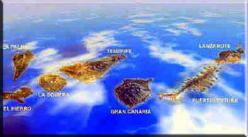
The Canary Islands are an autonomous community that forms a part of the Kingdom of Spain, and is made up of seven larger islands (Tenerife, La Palma, La Gomera, El Hierro, Gran Canaria, Lanzarote and Fuerteventura) and six smaller (Alegranza, Graciosa, Montaρa Clara, Lobos, Roque del Este and Roque del Oeste). The archipelago is situated in the Atlantic Ocean, in front of the African coasts; the northernmost point is 29Ί N and the southernmost 27Ί N. The whole territory occupies 7447 km2 and is the Spanish region with the longest coastline: 1583 km.
Canary islands vacation packages & sights

Canary Islands - History
The first inhabitants of the Canary Islands were the Guanches, a Berber race with light hair and features. Spain laid claim to the islands in the 1400s. The king of Mauritania, describing an expedition to the islands, referred to large, fierce dogs("canis" in Latin)hence the name Canaria. Arabs set up a trade business in 999. Many other groups, including people from Genoa, Majorca, Portugal, and France, visited the area in the 1200s and 1300s. Juan de Bethencourt was named king of the Canary Islands in 1404, and he eventually turned them over to his nephew. In the 1400s a Portuguese army took over the island of Gomera and held it for almost 60 years. A 1479 treaty formally gave Spain control of the islands, which were classified an autonomous community of Spain in 1982.
The first inhabitants came to the islands in successive waves, seemingly, from the north of the African continent. The development of the prehistoric cultures allowed the setting up of a very hierarchical social organization, with a political structure of monarchical character and a set of collective organs that met to solve military, political or juridical issues. Though this culture is generally known as guanche, this name belongs strictly to the inhabitants of Tenerife.
The Canary Islands were known in ancient times (Horatius and Plinius wrote about them), but it is since the 14th century when they began to be conquered by the Europeans. It is known that, since 1291, arrived to the archipelago several Genoese expeditions and, later, Catalan and Majorcan. In the 15th century, the Norman noblemen Jιan de Bethencourt and Gadifer de la Salle, who were in the service of the Castilian Crown, promoted the conquest. The seizure of the islands was achieved with difficulties and took nearly the whole century. The aboriginals suffered huge losses of population during the conquest, and in the following years their ethnic and cultural identity was progressively diluting and fading away with the massive arrival of settlers from the Iberian Peninsula.
During the 15th and 16th centuries, were instituted the Real Audiencia (territorial high court), the tribunal of the Inquisition, the Episcopal see and the cabildos insulares (insular councils) that, chaired by a governor (chosen by the king or the corresponding lord in some islands), ruled over the respective island.
In the 18th century the authority was transferred to the general commandants, appointed by the Crown, to the detriment of the powers of the cabildos and the audiencia.
Since 1871 the Canarian emigration towards Latin America was very important, a trend that became stronger during all the 20th century, especially to Cuba and Venezuela, being of an essential importance for the formation of the Canarian cultural identity.
The autonomous community is divided, since 1927, into two provinces: Las Palmas —encompassing Gran Canaria, Fuerteventura and Lanzarote— and Santa Cruz de Tenerife —with the islands of Tenerife, La Gomera, El Hierro and La Palma—. Furthermore, every island is considered as an administrative unit ruled by an insular council.
The Statute of Autonomy of the Canary Islands was approved on 10 August 1982. The transfer of administrative and political competences from Madrid gave, from the first moment, a wide degree of self-government. Due to an historical rivalry between the two provinces, the community established a double capital: Santa Cruz de Tenerife and Las Palmas de Gran Canaria. The insular councils, created in their modern version in 1912, have a great financial autonomy and wide administrative competences.
The Canary Islands have lacked throughout almost all their history a flag to represent to the whole of the islands. Each island was conquered under a different ensign, the Banners of the Conquest, having reached our days those of Fuerteventura, Gran Canaria, Tenerife and La Palma.
This kind are also the royal standards or guidons, such as the so-called "general flag", that the councilor Pedro de Vergara delivered to the Alferez Mayor (high standard-bearer) of Tenerife Francisco de Valcαrcel on 17 January 1561, ‘made of white, blue and yellow silk and with a red cross’, coinciding the first three colours with those of the current Canarian flag, a fact that lacking any other data can only be qualified as an astonishing historical coincidence. The same Alferez Mayor received some days later the royal banner, made of red silk and with a long point, having on one side the image of the Virgen de Candelaria (Our Lady of the Candlemas, patron saint of Tenerife) and on the other the royal arms, as well as the royal guidon with the arms of Castille embroidered in gold, silver and silk, with yellow edges.
Apart from these first exemples of particular and/or royal ensigns, throughout the following centuries the archipelago will know no more flags than those common to all the territories ruled by the Spanish monarchy, as it can be seen in the flags of the Canarian Provincial Corps preserved in the cathedrals of La Laguna and Las Palmas de Gran Canaria, all dating from the 18th century.
The first legal stipulation with respect to a flag for the Canary Islands is the Royal Order of 30 July 1845, establishing the maritime registry flag, distinctive of all the ports of the then single province, with capital in Santa Cruz de Tenerife, as a white saltire on blue background, a flag that eventually would remain as distinctive of the island of Tenerife.
By the time Christopher Columbus set sail in 1492, La Palma had not been colonised, (that it was, a year later) but, on a subsequent visit, some members of his first expedition introduced tobacco from the New World to the island. The island’s wealth is directly linked to its being one of only three Spanish ports that were allowed to trade with the Americas in the 16th century (Sevilla and Vigo were the others), and that wealth can be see in the lovely capital city of Santa Cruz de la Palma. More recently, in 1985, it became hombe to the most important space observatory in the northern hemisphere.
La Palma was approved as a Denomination of Origin in 1994, although vines were planted in the island in the early 16th century. The Consejo Regulador is located in Fuencaliente on the southern tip, where two technicians maintain a constant programme of control and assistance from the vineyard to he bottle. The DO La Palma is in the regions -Hoyo de Mazo, in the east, Fuencaliente, in the south, and Norte de La Palma in the north.
History tells us that from this Canary islands sail the vineyards for the countries of the new world, from America to South Africa, and the excellence of it's Malvasia wine was sang by Shakespeare. After a long lethargic period, new technology has raise wine quality, looking for those glory days of the sweet Malvasias while promoting some reds with a good image.
THE VINEYARDS
The vineyards encircle the island in a band between 200 and 1,200 metres, and total 1,200 hectares, with the possible addition of a further 300, mainly in the northwest. The terrain varies quite considerably from steep terraces -especially in the northwest, to easier, more level plots in parts of the rest of the island. The harvest takes place between August and November, with grapes collected by the families mostly at weekends.
Gran Canary
That was the name given to the island by its inhabitants before the arrival of the Europeans, in the XVth century. And one may assume that they had a fair opinion of their own courage since Bethencourt the Conqueror, is said to have given the island the title of "Grand" as a tribute to the indomitable bravery of its men.
This land with its regular shape has often been compared to a miniature continent because of the diversity of its climate and vegetation.
The deep ravines are mysterious scars that spread from its central volcanic massif like the branches of a star. Whenever you stand, the view stretches for miles on end, sweeping across mountains covered with pine or laurel trees, opulent over-cultivated valleys. The banana plantations spread like huge squares of yellow silk or the southern beaches are reminiscent of Africa.
Owing to its privileged location, this island quite naturally became a port of call in the Transatlantic Race. It has never ceased to attract merchants and seamen with its port and capital, Las Palmas.
Hierro
There, according to the Ancients, started the "Not Navigable Sea", marking the end of the world they knew. It is the most western Canary Island, the smallest too. It was pacified by Bethencourt who, when he arrived found the Bimbachos living on it. They were a pastoral people, of innocent mores. They liked dancing, ignored war and money.
The capital, Valverde, was given its name by Christopher Columbus when he discovered the beautiful gardens covering this quiet little town.
Tenerife
The largest island of the archipelago, Tenerife is interesting for the wide range of landscapes it offers. The massif of Anaga is a rocky backbone which runs North-East to South-West, separating the northern coast with its lush cultures, lulled by sweet breezes, from the less rugged southern part dug with ravines burnt by the sun and dried by the southern winds.
Dominating these naturally contrasted areas, El Pico del Teide, a volcanic cone of 3717 m, splendid in its regularity and majesty, is Spain's highest summit, watching over the place as well as over the other islands of the archipelago, like a shepherd, a big brother or a mineral god. Punctuating the lives of the inhabitants who are proud to show it to tourists, it gives them clues about the weather and reassures them when they go to sea or take the plane. They know that, long after they have left the island, they can still make out in the distance the bright peak of El Pico del Teide, which gave the island its name tenerife, the snow-capped mountain (in the guanche language- At the time of the rediscovery of the Canaries they were inhabited by an indigenous people called the 'Guanches'. We know from cultural similarities that the Guanches were Berbers from the mountains of Northwest Africa. How they reached the Canaries has been the subject of much speculation, particularly since at the time of the rediscovery they apparently had no knowledge of seafaring techniques - surprising for a people living on a small island with other nearby islands clearly visible).
As early as the XVth century the Guanche forbears of today's 500,000 inhabitants united with the Spaniards, adopting their names, language and religion.
The island became part of the kingdom of Castille in 1496 thanks to Alonso Fernández de Lugo who four years earlier had landed on the Eastern Coast to found Santa Cruz which was to become the capital.
La Palma
The island of flowers and cigars: that's how San Miguel de La Palma could be called. Life is so sweet there! The land has a surface of 726 km² and is very rugged. It is made up of mountains of well over 2000 m, like El Roque de los Muchachos that is 2423 m high.
Thanks to its western situation, La Palma enjoys a climate that allows all kinds of cultures - pine-trees high on the mountains, birch, laurel and walnut-trees on the slopes, bananas; tomatoes, coffee, grapes and tobacco grow from sea- level up to 600 m, amid the most gorgeous vegetation.
Alonso Fernández de Lugo painstakingly pacified La Palma in 1492 (nearly a century after Lanzarote, the first island conquered by Bethencourt). There he found a violent, proud and agile people, with an amorous nature and sharp intelligence: The Houarythes, whose defeated chief, Tanausu, starved himself to follow his people's suicidal customs and died before he reached Spain and thus became a national hero.
Lanzarote
As he was aware of man's curiosity, God is said to have wanted them to know about the moon. He divided the earth satellite into quarters and dropped the most beautiful one in the Atlantic. Is this the real origin of Lanzarote? We would be tempted to believe so. But after covering the 795 km² of Lanzarote which is the fourth Canary island, we must admit that this black and ochre, rocky landscape which is spiked with nearly 300 volcanic cones is more likely to have been born from the depths of the earth than those of the cosmos.
Where does the name of the island come? From a Genoese sailor, Lanceletto, who landed there in 1312? From a French baron called Lancelot who set foot on it, a century later? Or else from Jean de Bethencourt, a Norman gentleman, who, to celebrate the end of the pacification in 1404, is supposed to have broken a lance (Lanza Rota means broken lance) It seems that the last explanation is the most plausible. The guanche inhabitants, sorely afflicted by battles fought before Bethencourt's arrival, did not put up any resistance to the" Pacifier", who gave the island to the crown of Castille. It is worth noting that the Guanche wives were polyandrous. Each had three husbands who succeeded each other in turn, with the new moon.
As the Spanish were gradually taking hold of the other Canary Islands, Lanzarote, which was the first to be conquered, lost its influence. Protected by too small a garrison, its inhabitants were decimated, for centuries by the relentless attacks of pirates who were slave-hunters (like Amurat the Moor who only spared a few thousand people in 1586). Natural disasters can be added to the repeated blows of the pirates, in so far as a long series of volcanic eruptions shook the island. The last two (in 1730-1736 and 1824) turned the richest part of the island into a sea of lava. The ancestors of today's 45 000 inhabitants regained it by dint of hard work.
Fuerteventura
There is no tarbooch, no jellaba, and no minaret in sight, on the arid skyline. And despite of this, the island is so African in its blood that your first impression will be one of amazement, nearly one of deceit. This "skeleton" of an island as Unamuno put it, with its 2019 km² was called Herbania during the conquest and was famous for its pastures.
It is divided in two parts: la Maxorata, a high plateau in the north, is made of extinct volcanoes culminating at 250 m and the peninsula of Jandia, with the highest summit of the island, the Peak de Las Orejas (844 m) in the south. Fuerteventura is the second largest Canary Island for its surface but the smallest as far as the population is concerned (20 000 inhabitants).
Gracioza
This small island is located in the north of Lanzarote and there is a ferry link between Graciosa and Orzola (North of Lanzarote ), through the strait of El Río, in the morning and evening and also on request during the tourist season.
There are no tarred roads, no cars on the island... no shade either, only beautiful empty beaches, sand dunes and a small fisherman village - Caleta del Sabo - in which you can get board and lodging.
Tags: Canary islands travel guide, vacation rentals, hotels, package holidays, sightseeing, points of interest, car rental, city breaks, weather, sights and tickets.